The Influence of Sampling Methods on Pixel-Wise Hyperspectral Image Classification with 3D Convolutional Neural Networks
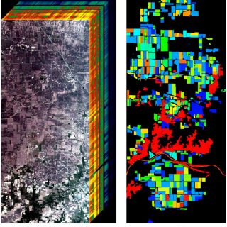
The Influence of Sampling Methods on Pixel-Wise Hyperspectral Image Classification with 3D Convolutional Neural Networks Lange, J., Cavallaro, G., Goetz, M., Erlingsson, E., Riedel, M.: The Influence of Sampling Methods on Pixel-Wise Hyperspectral Image Classification with 3D Convolutional Neural Networks, in conference proceedings of the IEEE International Geoscience and Remote Sensing Symposium (IGARSS 2018), July 22-27, 2018, Valencia, Spain [ EVENT ] [ DOI ] [ JUSER ] [ GOOGLE SCHOLAR ] [ RESEARCHGATE ] Abstract: Supervised image classification is one of the essential techniques for generating semantic maps from remotely sensed images. The lack of labeled ground truth datasets,...

 https://orcid.org/0000-0003-1810-9330